
4G LTE (and 5G) in BVLOS Drone Control
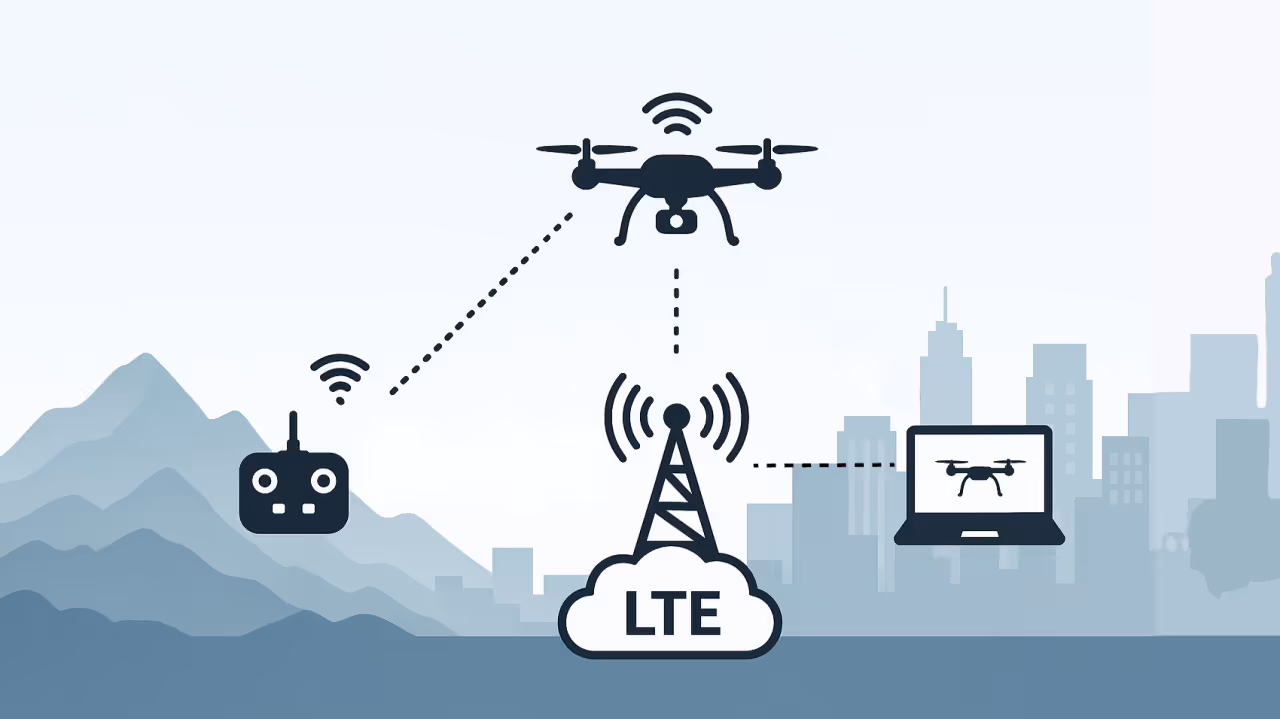
In today’s rapidly evolving drone landscape, beyond visual line-of-sight (BVLOS) operations are becoming increasingly common, and 4G LTE (“LTE”) is emerging as a pivotal enabler of this capability. Traditionally, drone control has relied on direct radio frequency (RF) links—typically handheld controllers communicating over short-range radio. However, as operational requirements expand and flight distances increase, LTE offers a compelling alternative, providing extended range, accessibility, reliable connectivity, and seamless integration with cloud-based systems.
5G coverage remains limited in many countries, with 4G LTE continuing to dominate across most deployed areas. While 5G is increasingly available in urban centres and high-traffic environments, it is still significantly less prevalent in rural and remote regions. The considerations outlined in this document apply equally to 5G where such coverage is available.
The Shift from RF to LTE
Drone control has relied on direct radio frequency (RF) links, which have long been the industry norm. However, these links are inherently limited by their range and line-of-sight requirements. Operators are constrained by geography, signal propagation, and atmospheric conditions. These limitations become especially pronounced in complex environments such as dense urban areas, coastal surveillance zones, mountainous regions, and operations from moving platforms like vehicles or vessels.
LTE overcomes many of these challenges by providing wide-area connectivity through existing cellular infrastructure, often spanning entire countries. This enables a drone to be launched from point A, fly beyond visual line-of-sight to point B, and remain in continuous contact with its operator. Such capability is essential for BVLOS missions, including infrastructure inspection, agricultural monitoring, logistics and delivery, and certain military or security reconnaissance tasks.
Real-World Examples and Altitude Capabilities
Real-world applications of LTE-connected BVLOS drone operations are increasingly documented. Use cases include infrastructure monitoring and healthcare delivery in rural Scotland, agricultural surveillance, and humanitarian aid missions in remote or conflict-affected areas. LTE has proven reliable in many field trials at altitudes of several thousand feet—well above the operating heights of typical RC-controller line-of-sight drones.
Research and trials across Europe and Asia have demonstrated consistent LTE performance at altitudes between 3,000 and 5,000 feet above ground level (AGL). This altitude envelope supports not only low-altitude commercial drone operations but also medium-altitude reconnaissance, security, and environmental monitoring missions—including military and dual-use platforms.
Command and Control: MAVLink and Beyond
For drones operating over LTE, MAVLink remains the dominant protocol for command and telemetry exchange. Originally designed for lightweight and low-latency communication, MAVLink enables transmission of flight commands, sensor data, and system status over TCP, UDP, or via VPN tunnels across LTE or other IP-based networks. Operators can remotely command the drone, monitor flight metrics, and receive real-time telemetry—even across long distances.
While MAVLink does not transmit video streams itself, it can be used to control onboard cameras and signal video stream availability or configuration (e.g. orientation, zoom, stream ID). Actual video feeds are typically streamed using separate protocols (e.g. RTSP or RTP) over parallel data channels.
This flexibility allows MAVLink-compatible drones to interoperate with a wide range of ground control software, user interfaces, and autopilot systems—even across national borders and cellular network boundaries. To improve resilience, some UAVs incorporate multiple LTE modems for redundancy, or implement onboard logic for dynamic network switching and failover.
It should be noted that there exist alternatives to MAVLink.
Alternatives to LTE
LTE is not the only communication option for BVLOS drone operations. Viable alternatives include:
- Starlink and Other Satellite Networks: Suitable for high-altitude, long-range missions—especially over maritime or remote regions lacking terrestrial coverage. Satellite links offer global reach but may introduce higher latency and require specialised antennas and power handling.
- Proprietary RF Links: Frequently used in military and high-assurance systems, these links employ encrypted, purpose-built protocols designed for anti-jamming resilience, spectrum agility, and secure command and control.
- Mesh Networks: In tactical or denied environments, drones may form self-healing, multi-hop mesh networks that enable peer-to-peer command/control relay, maintaining connectivity even without infrastructure or GNSS availability.
Despite these alternatives, LTE’s widespread coverage, ease of access, relatively low cost, and seamless integration with cloud services often make it the most practical and scalable solution for commercial, dual-use, and even selected military applications—especially where infrastructure is available and electromagnetic interference is limited.
Security Considerations
With the flexibility of LTE-based drone communications comes an expanded attack surface. UAVs that rely on mobile networks for command and control may be vulnerable to:
- SIM-based identification leakage, revealing IMSI or device identity to passive observers
- Session hijacking or redirection, particularly in the absence of robust authentication and mutual verification
- Interception of command and control traffic, especially if encryption is weak, misconfigured, or absent
- Location tracking or inference by third parties through analysis of signalling or data-plane behaviour
Understanding these risks is essential for drone manufacturers, network integrators, and mission planners. Effective countermeasures include strong authentication protocols, secure VPN tunnels (e.g. IPSec or WireGuard), use of private Access Point Names (APNs) to isolate drone traffic, and SIM provisioning strategies that minimise traceability.
Where possible, LTE-based command and control (C2) should be supplemented with out-of-band telemetry or backup communication links to ensure resilience and reduce single points of failure.
Regulatory Perspective
From a regulatory perspective, LTE-controlled drones present both challenges and opportunities. Aviation and telecoms regulators across Europe, the UK, and parts of Asia are actively developing frameworks to govern the safe use of public mobile networks for UAV command and control—particularly in the context of beyond visual line-of-sight (BVLOS) operations.
Several countries have issued preliminary guidance addressing topics such as SIM provisioning for UAVs, logical and physical network segmentation, and the designation of approved BVLOS flight corridors. These efforts aim to ensure separation from manned aviation, minimise interference, and enable lawful identification of UAVs operating via cellular infrastructure.
As BVLOS adoption grows, civil aviation authorities are increasingly collaborating with mobile network operators (MNOs) and counter-UAS stakeholders to define how LTE- and 5G-based control systems can coexist with traditional aviation frameworks and contribute to the protection of critical infrastructure.
A future regulatory model may include a national register of C2-enabled UAVs, combined with mandatory flight authorisation, real-time tracking, and remote identification obligations—creating accountability while enabling safe integration into shared airspace.
Strategic Relevance for Defence and Policy
The rise of LTE-controlled drones introduces new strategic challenges for defence, intelligence, and national security agencies. These systems—capable of operating over public cellular infrastructure—raise pressing questions:
- How can legitimate UAV operations be distinguished from hostile or unauthorised use on LTE networks?
- What responsibility and technical capability should mobile network operators (MNOs) have in detecting or mitigating such misuse?
- How can we protect critical infrastructure from LTE-connected reconnaissance drones, loitering munitions, or improvised threat platforms?
Understanding how these drones connect, move, and behave within mobile networks is critical. It enables the development of enforcement, detection, and attribution capabilities that support national airspace integrity and infrastructure protection.
This is precisely where systems like the LTE S1 Analyser from Melrose Networks become essential—by passively ingesting and analysing LTE control-plane signalling, such platforms can infer UAV presence, movement patterns, and behavioural anomalies without requiring additional sensors or RF interception. This creates a powerful, network-based layer of situational awareness that can complement traditional counter-UAS measures.
Conclusion
LTE is rapidly emerging as a foundational technology for beyond visual line-of-sight (BVLOS) drone operations across civilian, commercial, and defence sectors. With its extensive coverage, proven network reliability, and compatibility with command-and-control protocols such as MAVLink, LTE offers a high degree of operational flexibility and scalability.
However, this adoption also introduces new risks—ranging from unauthorised use and cyber vulnerabilities to policy and regulatory uncertainty. The same infrastructure that enables legitimate BVLOS operations can also be exploited by adversaries or non-state actors.
By developing a comprehensive understanding of the LTE drone ecosystem—including its enabling technologies, protocols, threat vectors, and regulatory considerations—stakeholders can design and deploy more resilient solutions. Whether building UAV platforms, managing airspace, or protecting critical national infrastructure, this knowledge is essential for shaping secure and effective C2 environments.
Melrose Networks — Leaders in mobile network–based drone detection and tracking.