
Co-Channel Interference Effect of High-Altutude Drone
𝗖𝗼-𝗖𝗵𝗮𝗻𝗻𝗲𝗹 𝗜𝗻𝘁𝗲𝗿𝗳𝗲𝗿𝗲𝗻𝗰𝗲 𝗘𝗳𝗳𝗲𝗰𝘁 𝗼𝗳 𝗛𝗶𝗴𝗵-𝗔𝗹𝘁𝗶𝘁𝘂𝗱𝗲 𝗗𝗿𝗼𝗻𝗲
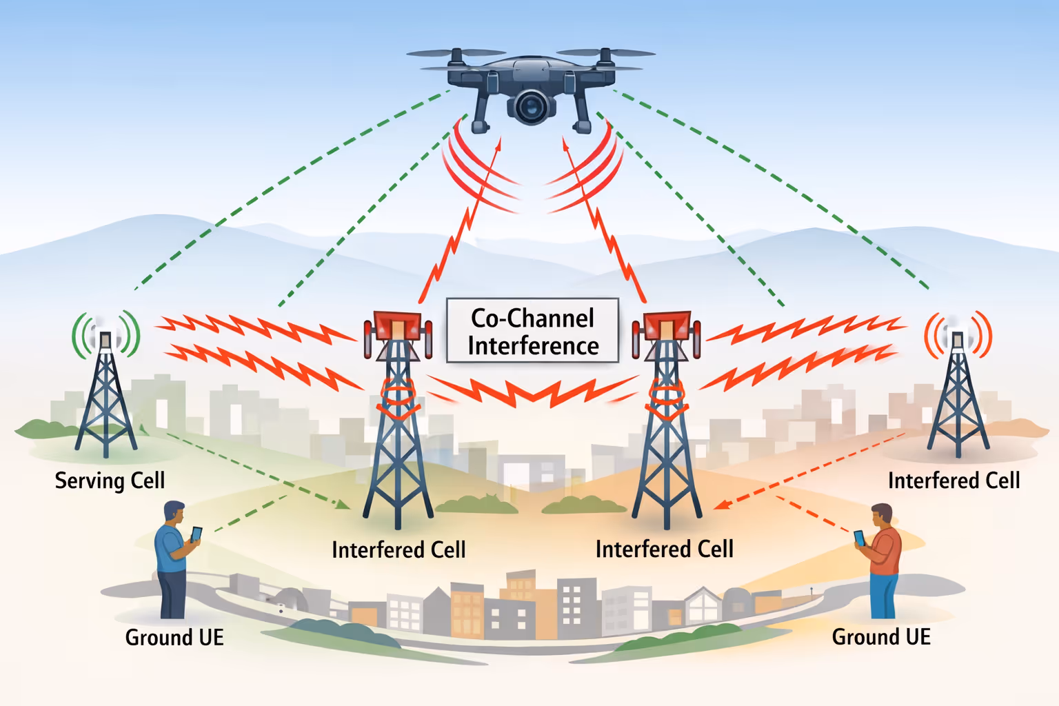
When a cellular-connected drone operates at altitude, its modem can establish line-of-sight visibility to a large number of near and distant base stations simultaneously. Unlike terrestrial devices that are typically served by a small number of nearby cells, an airborne user equipment (UE) may be received by multiple geographically separated cells that reuse the same uplink spectrum.
As the drone transmits, these cells may receive the drone’s uplink energy on the same frequency resources used by their own UEs. This creates co-channel interference across the network, raising the uplink interference floor and disrupting the base stations’ ability to reliably decode transmissions from terrestrial users sharing the same spectrum. The result can be increased HARQ retransmissions, packet loss, reduced throughput, and degraded service for ground UEs across multiple cells.
A cellular-connected drone operating at altitude may itself experience co-channel interference primarily on the downlink, where signals from multiple base stations using the same frequency can arrive simultaneously at the drone’s receiver. In terrestrial conditions, a ground UE is typically dominated by the serving cell’s signal, while signals from neighbouring co-channel cells are attenuated by terrain, buildings, and antenna patterns. At altitude, however, the drone can have line-of-sight to several base stations at once, including adjacent cells transmitting on the same channel. These additional downlink signals act as interference relative to the serving cell’s transmission, reducing the effective signal-to-interference-plus-noise ratio (SINR) at the drone. As the drone moves and the geometry between the drone and surrounding cells changes, the interference environment can fluctuate, leading to variable downlink quality, reduced modulation and coding efficiency, increased decoding errors, and potentially degraded throughput or mobility signalling performance.
As the drone moves across the coverage area, the interference footprint effectively rolls across the geographic region, affecting different cells as the airborne UE becomes visible to new sectors while moving away from others. This creates a moving pattern of uplink interference that can degrade service for terrestrial users across a wide area of the mobile network.
This behaviour is an inherent consequence of frequency reuse in cellular networks combined with the extended radio horizon of airborne devices, and it illustrates why high-altitude cellular-connected drones can have a disproportionate impact on uplink performance across multiple cells simultaneously.
Importantly, this behaviour is detectable through signalling analysis of the S1AP (LTE) or NGAP (5G) interfaces, where the distinctive mobility and session patterns of airborne UEs become visible at the mobile core network.